Showing posts with label Mississippi River bike connections. Show all posts

Sunday, March 13, 2016

Small Mistakes Will Cause Big Problems for Bikers on 26th Ave

Northwest corner of 2nd St and 26th Ave N
Last fall, several northside bicyclists got together to see how the 26th Ave bike path was shaping up and to take a look at possibilities for riverfront connections at the end of 26th.  That's when we noticed the curb cut above.  The problem with this design, in case it's not obvious enough, is that the sidewalk and the bike lane bottleneck right at the point where we also have a fire hydrant.  There is literally no way for a biker to get on or off the bike path without either jumping a curb into traffic or jostling for sidewalk space with pedestrians.  Thanks to the building that abuts the sidewalk, there isn't even anyplace else for bikers or pedestrians to go to avoid conflicts with vehicular traffic.

We chalked that error up to the possibility that larger trucks along the industrial corridor may need a wider berth for their turns.  And for the time being, there will be very few pedestrians and bikers starting their route on the east side of 2nd.  Until a 26th/riverfront connection is cemented, there isn't much of a reason for bikers to be on the other side of this intersection.  So we chalked this up to one more mistake in a series of bad designs between Washington Avenue and north Minneapolis river connections.

That is, until we saw...

Sunday, August 21, 2011

Metrodome Festivities


Post, photos, and images by the Hawthorne Hawkman.

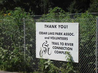
Saturday marked the re-opening of the Metrodome, with a portion of the event aimed at thanking tornado volunteers and building community.  I was one of the first 3,000 people to enter, and so I received a commemorative piece of the previous teflon roof that collapsed in last winter's snowmaggedon.  I took a roundabout way to get to the Dome, in order to bike along the final segment of the Cedar Lake Trail.  That particular connection to the Mississippi River cost $9.2 million and took over 11 years to complete.  A similar, more ambitious, connection in NoMi could take even longer to build.  That's no reason to get rid of the proposal entirely, as some groups are recommending.

The Cedar Lake connection to the Mississippi River is quite the sight though...

Sunday, November 14, 2010

Lowry Bridge Will be Built the Right Way!

Photo found here.

Photo found here.

Image from the Lowry Bridge homepage.
Post by the Hawthorne Hawkman.  Photo sources included in hyperlinks in photo captions.

Not too long ago, the Irving Inquisition blog and I had ourselves a disagreement over whether it would be best to build the Lowry Avenue Bridge quickly, or if we should wait until enough funding was allocated so that a NoMi bike/walk path underneath could be built in accordance with the Above the Falls master plan.  We'd heard rumblings that our side of the bridge would not extend far enough for that path to be put in place.  The Irving Inquisition position was to build it sooner, regardless of whether it met any comprehensive plans.  My stance was to wait however long it took so that we get it done right.  If the plan is a 50-year plan, and the bridge will last for 100 years or more, then there's only one shot at getting this amenity or NoMi.

Well, it turns out we were both right.   (but I was more right)  According to Tom Leighton at the most recent Hawthorne board meeting, Hennepin County and Mark Stenglein were diligent in pursuing enough funding so that the bridge can be built with the space for a bike/walk path underneath, and this won't cause any significant delays in construction.  Connecting the North Mississippi Regional Park and the rest of the Grand Rounds (admittedly, the full connection will take many, many years to complete due to property acquisition) will do wonders for biking in and through NoMi.

On a somewhat random note, as I was searching for images to use for this post, I came across another Lowry Bridge, this one in Manchester, England.  Notice any similarities?

Photo found here.

Photo found here.

Monday, August 30, 2010

Can't Get There From Here

Facing south just off of 26th and Pacific
26th dead-ends before it can reach the Mississippi River.  To add insult to injury, this sorry excuse of a cul-de-sac is often strewn with litter.
Just north of the end of the bike path along the river, we can just about see 26th Ave.
Just imagine what it would be like for Hawthorne residents if we could bike down 26th, hang a right, and see this view in an instant.
Post and photos by the Hawthorne Hawkman

I've hinted at this once before, but the Hawthorne neighborhood's connection to the Mississippi River is woefully under-utilized. Broadway Pizza doesn't take advantage of it, there was no synergy between the Aquatennial and FLOW this year, and if you want to get to the River from the residential sector, you have two choices: take Broadway (which is not a pedestrian-friendly stretch at this juncture) or zigzag through an industrial corridor.

Furthermore, as Hawthorne has done neighborhood surveys for our second round of NRP funding, we've found that most residents don't identify the river as something that's truly a part of our community. "That's for rich folk," is a common refrain. If we had an easy way to get directly to the Mississippi from 26th, I guarantee we'd hear a different tune. Not only that, but property along 26th Avenue and the eastern edge of the neighborhood would almost certainly become among the most desirable spots in the city.

Now, if we really want to get technical...